
Why does a PMIS need both ERP and GIS?
Why does a PMIS need both ERP and GIS?
GISGRO combines ERP and GIS in one visual PMIS platform, connecting port operations, invoicing and infrastructure. By turning connected data into actionable insights, ports can optimize revenue and make smarter decisions.
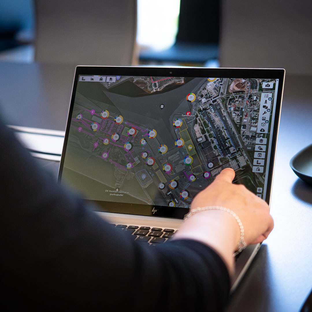
Why does a Port Management Information System (PMIS) need both Enterprice Resource Planning (ERP) and Geographical Information System (GIS)?
A PMIS brings structure to many sides of port operations. But ports are physical environments, and much of the information managed in a PMIS is connected to something happening at a specific location and time.
This is where we believe the real value of a modern PMIS lies. When ERP-related functionality is connected directly with a GIS-based operational view, information gains context. Instead of managing business processes in one environment and the physical port in another, teams can work with one connected picture of what is happening, where it is happening and what commercial or operational consequences it creates.
GISGRO is a PMIS that combines ERP and GIS in one visual, connected and easy to use platform. ERP functionality manages the processes and relationships behind port operations, while GIS connects that information to the physical port. Together, they create a PMIS that reflects not only the processes taking place in the port, but the port itself.
How to handle separate records of the same port activity?
Ports generate an enormous amount of interconnected information. Port calls, cargo, services, customers, contracts, tariffs and invoices form the business side of the operation, while berths, quays, storage areas, equipment and other infrastructure form its physical environment. Both sides describe the same port activity, yet the information is often managed in different systems, records or organisational contexts.
A port call illustrates the problem well: From an operational perspective, it is a vessel arriving at a particular berth at a particular time, requiring certain services and perhaps handling cargo. From a commercial perspective, the same event consists of a customer, contractual conditions, services, tariffs and eventually an invoice. From an infrastructure perspective, it represents the use of a berth, quay and potentially other port assets.
These are not separate events. They are different records and perspectives of the same event.
When the information behind them remains disconnected, each function can still do its job, but some of the context is lost between processes. Operations knows what happened at the berth, finance knows what was invoiced, and infrastructure management knows which assets exist, but connecting those pieces afterwards requires additional work and often goes hand in hand with recording the same data manually multiple times. A PMIS becomes much more valuable when those relationships are maintained from the beginning, and relevant data is shared automatically.
What ERP and GIS each contribute?
ERP functionality provides the structure for managing processes and commercial relationships. It connects vessel calls with customers, services, cargo, contracts and tariffs, allowing information created during port operations to continue into invoicing, reporting and other administrative processes.
GIS contributes a different kind of information: spatial context. A berth is not simply an identification number in a database. It is a physical part of the port with a location, dimensions, structures, equipment, restrictions and operational history. The same applies to quays, storage areas, roads, utilities, buildings and other infrastructure.
Bringing these capabilities into the same PMIS connects the business process with the physical environment in which it takes place. ERP can tell us what happened, when, for whom and with what commercial consequences. GIS adds where it happened and which physical assets and areas were involved.
Neither perspective replaces the other. Their value comes from the connection between them. When ERP and GIS share the same underlying information, port data retains its operational, commercial and spatial context throughout its lifecycle.

One port call, from berth allocation through services to invoicing
Consider the lifecycle of a single port call. Before arrival, the vessel needs to be scheduled and allocated to a suitable berth. The operational team needs information about the vessel, timing, cargo and required services, together with an understanding of the berth and surrounding infrastructure.
As the port call progresses, activities create additional information. Services are provided, cargo volumes are recorded and infrastructure is used. These operational events can also have commercial consequences. Services may need to be charged according to contracts or tariffs, and vessel or cargo information may determine other port fees.
When ERP and GIS functionality are part of the same PMIS, that event can become a common source of information across the organisation. Data created during the operational process can continue into commercial workflows and reporting instead of being collected again for each purpose. In practical terms, the same connected data can support:
- operations, including port calls, berth planning, cargo and services;
- commercial and financial processes, including customers, contracts, tariffs and invoicing;
- asset management, reporting and planning, where historical operational information can be viewed in the context of the port’s physical infrastructure and the situation on the ground.
This creates value not simply by reducing duplicate data entry, but by maintaining the relationship between information throughout its lifecycle.
From port operation to invoice without losing the connection or data
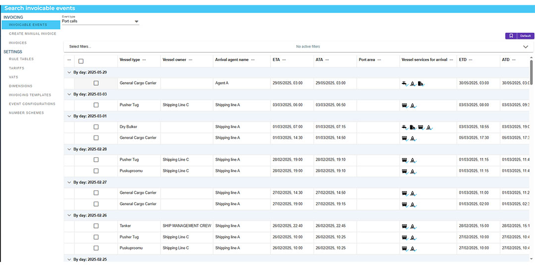
Invoicing is a good example of why this matters. A port invoice is ultimately the commercial outcome of something that happened operationally: a vessel called at the port, cargo was handled, infrastructure was used or a service was provided. Yet in disconnected systems, the information used for invoicing may gradually become separated from the event that originally created it or even get lost in the way.
Connecting ERP functionality with operational data keeps that chain intact. Vessel information, services, cargo volumes, customer-specific agreements and tariffs can form part of the same workflow, allowing invoiceable events to be created from the underlying port activity. Finance can still review and approve the information, but it does not need to reconstruct the operation in order to understand what should be charged.
This creates a clearer relationship between the operational event, the service provided, the applicable pricing logic and the resulting invoice. It supports accuracy and traceability while also making collaboration between operations and finance more straightforward.
GIS makes ERP data visible in the context of the real port
The value becomes even more apparent as historical information accumulates. ERP data can tell you how many vessels visited the port, how much cargo was handled, which services were delivered, and what was invoiced. When that information is connected with GIS, it can also be examined in relation to where those activities took place.
That opens a different perspective on the same data. Instead of looking only at tables and reports, ports can understand activity in relation to berths, areas, infrastructure and assets. Operational history can therefore contribute to questions about infrastructure utilisation, maintenance, capacity and future development.
For a port, this spatial dimension matters because so many business decisions ultimately relate to physical assets. Investments are made in quays, fairways, storage areas, equipment and other infrastructure. Understanding how those assets connect with actual operational activity creates a stronger information base for deciding how they should be maintained, developed and used. In addition, it gives some perspective to how the port’s infrastructure developed over time.
One source of truth does not mean same information for everyone
Connecting ERP and GIS does not mean every person in the organisation needs to see the same screen or work with the same information. Operations, finance, management and infrastructure teams have different responsibilities and naturally need different views. This prevents an overloaded user interface.
What matters is that those views are built on connected information.
Operations can concentrate on today’s vessel traffic and services while finance works with contracts and invoicing. Infrastructure teams can focus on assets and maintenance, while management looks at KPIs and longer-term trends. Because the underlying information is connected, teams can work from the same operational reality without maintaining separate versions of it.
This is an important difference between simply collecting data in one place and actually connecting it. The objective is not to create a bigger database but to make the right data available to the right person at the right time. The task is to make information useful across the organisation while preserving the relationships between operations, commercial processes and physical infrastructure.
A PMIS that reflects how a port actually works
Ports do not operate as separate administrative, financial and geographical worlds. A vessel arriving at a berth, the services it receives, the infrastructure it uses and the invoice that follows are all parts of the same process. A valuable PMIS should reflect that reality.
This is the thinking behind GISGRO’s combination of GIS and ERP in one visual PMIS platform. ERP-related processes such as port calls, services, cargo, customers, contracts and invoicing can be connected with the port’s geographical information, infrastructure and assets, creating a shared environment for managing both the business and physical sides of the port.
The result is more than having several functions available through one system. The real value comes from the connections between them. Operational information can become commercial information optimizing revenue without losing its context, historical activity can support infrastructure planning, and different teams can use the same underlying data for their own purposes.
For us, that is where a PMIS becomes particularly valuable: when ERP provides the structure, GIS provides the context, and together they create a more complete view of the port.
GISGRO – Control the data. Control the port.
Book A Demo
Real people. Real support.
Whether you’re curious about how GISGRO could work for your port or you’re ready to take the next step, we’d love to hear from you. Our team is friendly, experienced, and happy to help.
Just fill out the form and we’ll get back to you soon.